Good times!
Although we've left the Bahamas, I will always remember the image of Annie checking e-mail from tiny Helen's Island just off Normans Cay. There is nothing on this island but this one palm tree. It's not the most likely place in the world to get a wireless Internet connection, but who knows?
April 19 - Punta Gorda, Charlotte Harbor
When we arrived at the fuel dock at Fisherman's Village marina in Punta Gorda, our former dock neighbor Cindy Brown was waiting for us. Some years ago Steve and Cindy were the first people we met when Annie and I walked out on the docks at Sale Creek Marina. Later they sailed their Bayfield 29, Reflection, down to Punta Gorda...and now we know why. What a great town!
After fueling we anchored about a half mile off the marina and then went in to the dinghy dock ($15/day but the facilities, including a heated pool, are excellent) to join Steve and Cindy for a visit to the park and well appointed playground nearby. Next we drove to their beautiful nautically-themed home, where Laura swam in their pool and we enjoyed a delicious meal. It was "gallery night" in downtown Punta Gorda, with crowds of people wandering through the shops and art galleries. Every block or so there were musicians entertaining outside. In fact, every Thursday night is a treat in Punta Gorda, because back at the park, all the musicians who weren't already playing at a gallery had gathered to jam. On Thursdays people with talent show up with an instrument, sitting down on a bench by themselves or joining one of the groups in the pavilions to play along. In the big pavilion, at least a dozen guitars were picking in the background of every bluegrass tune.
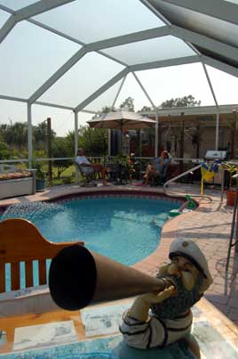
Photos: (1) Pools are pretty common in Florida--the grocery stores have a big selection of chlorine and filters--but Steve and Cindy have a particularly nice one. (2) Scene at the park with Seaductress barely visible on the horizon.
April 20 - Englewood, 15 miles north of Charlotte Harbor
The forecast did not bode well for an offshore route north, so we decided to spend the morning in Punta Gorda. To Laura's delight we revisited the playground and then had some delicious ice cream at Cubby's, a short walk further. Shortly after Noon we were back on the boat and motoring south down Charlotte Harbor. With the wind scheduled to build and switch to the northeast during the night, none of the easy anchorages looked appropriate, so we decided to make some miles up the inside route on the ICW. While we generally prefer the "hands-off" nature of the open waters, I have to admit that the inside waterway is interesting. There are boats, houses, birds, mangroves, channel markers to be followed, wakes to be dodged...and of course there are anchorages, which don't exist on the "outside." The anchorage here in Englewood is not bad, even if we did have to put out two anchors to keep ourselves centered in a narrow piece of water. I figured the hassle of two anchors would take less time than waiting for the tide to lift us off the mud in the morning.
April 21 - Manatee River near DeSoto Point, off Tampa Bay
We went through four more bridges today on the ICW (making a total of five since Charlotte Harbor) to get to the Venice Inlet, where we went back out into the Gulf. We had come in the inlet to anchor overnight in Venice on our way south, so it was nice to close the circle and approach from inland. With winds building out of the northeast, we turned into Tampa Bay a few hours later and anchored with a widely-spaced crowd of other boats on the eastern side of the Manatee River. We'll get up early in the morning and strike out for Clearwater.
April 23 - Gulf of Mexico
I've said it before, and here I go again: the best part of cruising is the people. I had the same experience in my hikes on the Appalachian Trail. At first, I used to find places well off the trail to camp where I could have the world all to myself. I had a Thoreau-like image of myself alone in the wilderness, reveling in the solitude, and that part of the experience is indeed sublime. But after a while I discovered that the most memorable experiences were the people that I met along the trail. Paradise is even better when it's shared with the right people.
It was great fun to spend an evening with Wm and Carolina Shrewsbury in Clearwater Beach. Wm (I know him as "William" but it's spelled more efficiently) is from Chattanooga. I've known him for years--there are probably not many cavers in the southeast who don't know Wm--so it seems a little amazing that we would see him and his wonderful wife Carolina living here in Florida on a sailboat. For them, for all those. They have an entertaining log of their trip south at www.hawaiiflow.com, with plans to get a larger boat and continue south in the next few years. Coming on the heels of the hospitality we enjoyed at the hands of Steve and Cindy Brown, this week makes me appreciate we're fortunate to have such friends. Although our tight schedule didn't make it possible to meet, I also enjoyed talking with another of my cruising mentors, Tom Pride, who we hope to see again back in Tennessee one of these days.
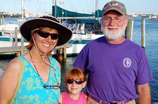
Photo: Carolina, Laura, and Wm. Encountering old friends who have likewise made the cruising plunge is one of the surprising and most enjoyable parts of our trip. Disney had it right: it's a small world, after all.
We left Clearwater Beach Municipal Marina around 10:30 AM after a morning spent in preparation: filling up the water tanks, cleaning the bilge, changing the engine and transmission oils, plotting a complicated series of warping maneuvers to get us gracefully out of the dock in the gusting breeze (it would have worked, too, if I had remembered to untie that blue line at the proper moment). As I write this we are about 30 miles out into the Gulf in very mild--which is to say, motoring--conditions, looking forward to a peaceful passage towards St. Joe Sound, Pensacola or perhaps further.
April 25 - Ft. McRae Anchorage, Pensacola
This morning we motored in the pass at Pensacola, where what seems like half a lifetime ago our little boat of Tennessee lake sailors made our first venture into big water. Here is where we walked the first of hundreds of beaches, picked up our first sea shells. Here is where--in truth it was just sixteen months ago--we left the inland waterways behind for bigger dreams.
Going south, it took us over three weeks to get from Pensacola to Clearwater. Coming home, we covered that distance in just over 48 hours, motoring straight across the Gulf and then along the Panhandle, a distance of around 275 miles. The seas and light wind were both from the stern, so the motion was fairly comfortable, although we did tend to roll around a bit. Once we got away from Clearwater I saw just one other boat (a sportfish that came out of oblivion to cross just a hundred yards off our bow) and one NOAA weather buoy; otherwise it was just water and sky. Of course, in just two nights you can't really get adjusted to the rhythm of a boat at sea. I read one novel and watched three movies, plus two seasons of Curb Your Enthusiasm. Meanwhile, Annie found time to write a short essay reflecting on our trip.
Our first night out Laura and I grilled a Spanish Mackerel that we caught; late yesterday afternoon we pulled in two Skipjack Tuna. We'd heard conflicting reports about just how tasty Skipjack might be, but the thick steaks Annie baked last night were delicious. Perhaps the secret is to filet them immediately as we did (or perhaps they weren't Skipjacks at all, since we can't find our fish book to be sure).
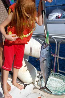
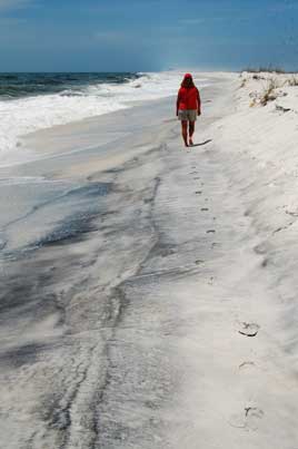
Photos: (1) While we were reeling in one tuna, this one jumped on the other line. (2) After arriving at Ft. McRae, we went for an afternoon walk on the beach. This was the first beach we walked on the trip, and now it's very likely the last--at least for this cruise.
April 28 - Dog River Marina, Mobile Bay
Yesterday morning we were peacefully at anchor in Ingrahm Bayou with the birds calling to us, but by late afternoon we were surrounded by the incessant beeps of the checkout scanners at a Super-Walmart. America...land of contrast.
We received a warm welcome back to Dog River Marina from Ricky the dockmaster, and knew why we wanted to come back to this place. We filled up with 35 gallons of diesel and took the courtesy car (a white Crown Victoria, big engine and all, just like the cops drive) over to Hertz to pick up a rental car. Today we're driving over to Ocean Springs to visit Annie's family.
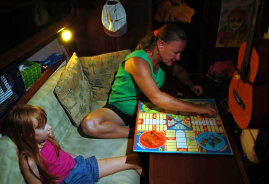
Photo: No matter how hard we try, we can't beat Mom at Parcheesi.
April 29 - Big Lizard Creek (TennTom Mile 20)
We left Dog River yesterday afternoon after a driving tour of Mobile as we returned the rental car (it's amazing how small details like turning left instead of right can, like the wingbeat of a butterfly, have dramatic consequences). We had a good visit the previous day with Annie's family at a backyard gathering completed with boiled shrimp, crab, corn, and potatoes.
Once past the busy seaport of Mobile, we entered the scenic waters of the Mobile River. Big Lizard Creek, twenty miles north, proved to be an excellent anchorage for the night, deep and wide enough (barely) to swing on just one anchor--although I put down two. The entrance had at least seven feet on the centerline, with twenty to thirty feet inside. It's strange to look out the window and see the trees just twenty feet away. Interstate 65 is close enough that we can hear the traffic, but otherwise this is a wonderful spot.

Photos: (1) Wouldn't you know it? We missed a few cruising destinations. Reverse course! (2) Laura made some new friends in Mississippi. (3) Quietly at anchor in Big Lizard Creek.
April 30 - Three Sisters Lake (Mile 63)
Three Sisters looks to be a pretty good anchorage even if it doesn't match the sketch in the Rumsey Guide or the chartplotter (there's no island at the entrance and no side creeks). Hugging the side of the creek, just ten feet off the downstream shore, we had ten feet of water going in. Rather than continuing a couple of hundred yards to the lake itself, we put down bow and stern anchors in a shady spot not from the river entrance.
I heartily recommend having both the Rumsey (Tennessee River, Tenn-Tom Waterway, and Lower Tombigbee River) and Myers (TennTom Nitty-Gritty) guides when cruising this water. Sometimes one will have a good anchorage listed that the other missed entirely. Myers is more up-to-date and pragmatic. The Rumseys include many more details and anchorages, most with sketch charts. You have to keep in mind that even local knowledge is subject to change on these shifting waters. The reference we use the least is the official charts of the river. I haven't even gotten them out for the trip north. Our Raymarine chartplotter has more information and typically keeps us better informed, even if the fluxgate compass on the autopilot sometimes has the boat pointing in the wrong direction.
Photos: (1) There's plenty of water if you hug the downstream shore on the entrance, shown here. (2) A view of the ship from the TennTom. When you hear those tugs going by in the night, you want to know you're back far enough to be out of their way.
May 1 - Turkey Creek (Mile 120)
We spent another beautiful day on the water chugging upstream, watching butterflies and birds that flit around the boat, bald eagles and hawks, herons and egrets. Mostly we are traveling through what looks like wilderness, but occasionally there are some nicely redneck touches of civilization: run-down trailers flying faded Confederate flags, a Lazy Boy recliner set out on an isolated sandbar with at least sixty empty beer cans around it.
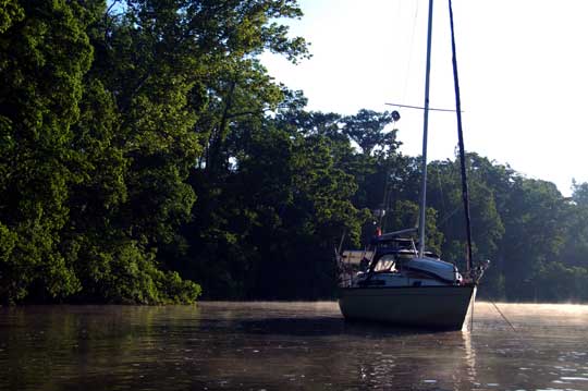
We had to wait almost two hours for a southbound barge to lock through the Coffeeville Dam, the first of 17 locks between us and Chattanooga, but that's life on the waterway. The hour being late (and a trawler having already taken the dock at Bobby's Fish Camp) we poked our way into Turkey Creek, a very narrow but fairly deep creek just three miles above the dam. Although turning around was difficult, we got bow and stern anchors out with just barely enough room for the bass boats to squeeze by, just far enough out of the river to sleep soundly without worrying about barges visiting us during the night.
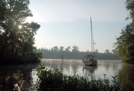
Photo: Turkey Creek is surrounded by a wildlife refuge and makes for a pleasant overnight stop, despite a few mosquitoes during the night (they were gone by morning).
May 2 - Barrons Landing (Mile 168)
After Bashi Creek at Mile 145, where we ate Thanksgiving dinner in 2005, there are no deep places to get off the river for the next seventy miles. It was barely lunchtime when we passed Bashi Creek, so we kept going another twenty miles to Barrons Landing. Technically, Barrons isn't really an anchorage, just an indent in the river where a boat can get out of the path of the river traffic. We anchored with bow and stern anchors to hold us parallel to shore in about fifteen feet of water.
With the days getting longer, we could probably have made Demopolis had we started at dawn. Instead, our leisurely departure from Turkey Creek was delayed this morning when I noticed that we had broken the stud on a motor mount. Apparently I had unintentionally backed the stud out of the mount, exposing it to too much lateral stress. Fortunately, I had kept the old mounts when I replaced them several months ago, so we had parts at the ready. In less than an hour I had swapped the mount and we were finally underway.
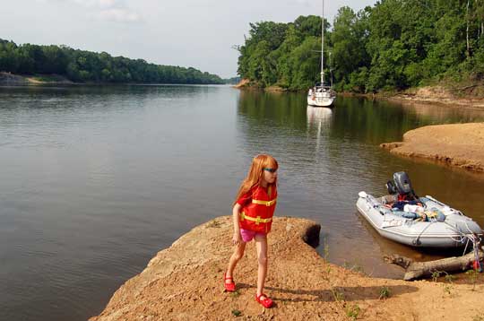
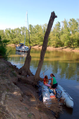
Photo: Laura enjoyed exploring the shore around Barrons Landing. There is a boat ramp with a picnic area on the opposite shore, but alas, no playground or cell service here.
Next Two Weeks | Previous Two Weeks | Start of Log

![]()
Copyright © 2007 by Rodger Ling.
All rights reserved.
