November 2, 2006 - Deltaville, Virginia
 Today, with the boat still sitting in its jack stands at Deltaville Boatyard, we celebrate the one year anniversary of our departure from Sale Creek into the blue. How happy we were, how little we knew of what awaited us! And how little we still know! I suppose the most relevant question, now that we are no longer first-year cruising plebes (we've been promoted to cruising novices!) is this: knowing what we do now, would we do it all again?
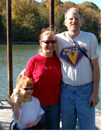
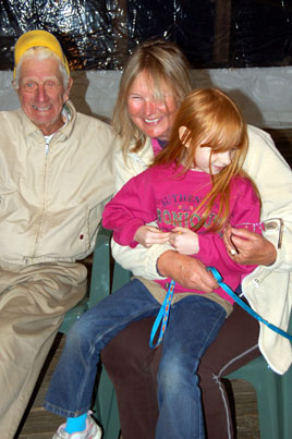
Absolutely. I can't speak for Annie and Laura, but I will, anyway. I envy all the cruisers we meet who are heading south for that magic first year, and when I look at the picture of us standing on the dock at Sale Creek a year ago I almost can't believe that we were clever enough to be one of them.
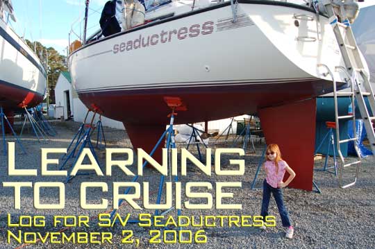
Photos: (Title) She's looking pretty spiffy, and the boat's not half bad either. Believe it or not we actually waxed the topsides. See also: alternative title shot. (At Left) November 2, 2005,
November 3, 2006 - Deltaville, Virginia
The boat was "splashed" and at the fuel dock (19 gallons) by Noon, but as the tide was falling and we had good wireless access here, we decided to anchor here in Deltaville for one more night. What's one more when you've already been here a week? Unfortunately, it's a cold night, with temperatures below freezing. I hope to get up early tomorrow morning and get down the Bay to Hampton, not far from Norfolk. The most fun we had today (aside from paying the bill, which actually wasn't fun) was probably talking with Rob and Sue of Mandate, a Chris Craft Apache sloop they are cruising to the Bahamas for the winter.
November 4, 2006 - Hampton, Virginia
We made it up the Hampton River to the public dock after eight hours of motor-sailing. I had intended to anchor, but most of the good spots were already claimed, so we struck a deal with the very nice Hampton dockmaster for $1/foot. The best part is that we are plugged in and have heat to combat the chill.
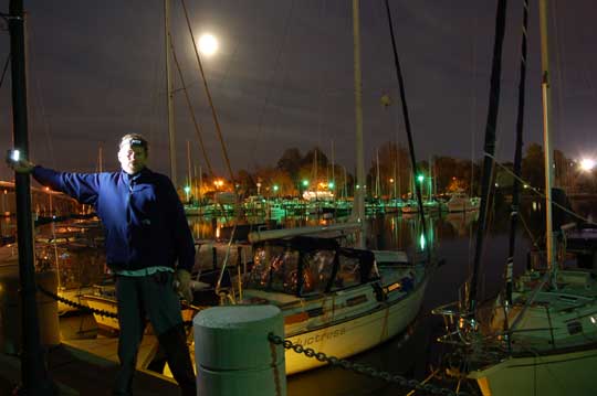
Photo: Seaductress at the public dock in Hampton. This is a very friendly town and a great place to visit.
November 5, 2006 - Dismal Swamp Canal, North Carolina
Coming north we took the Virginia Cut canal up to Norfolk, so on the return we were determined to go through the more scenic Dismal Swamp. We approached the route with both anticipation and trepidation. Completed in 1805, the canal has a depth of only six feet at its center. Barely sixty feet wide, it looks more like something I would take a canoe down rather than a sailboat that draws just a bit less than, well, six feet. The canal has a reputation for hiding sunken logs that occasionally whack against a passing keel. Yet when we had asked our friend Godwin for his opinion of the canal, he had said, "There are two kinds of people: those who say you cannot get through and those who go through." We were determined to be in the latter category.
The approach to the canal involved a long motor past all the naval ships at Norfolk (only one aircraft carrier was left--are we getting spread thin?), through a total of four lift bridges (two of which are up most of the time), and finally a wait of about two hours at the Deep Creek lock because we just missed the 11:00 locking. There are only four scheduled lockings each day to conserve the water in the canal. Robert, the friendly lockmaster/bridge tender (he also drives over and opens the bridge near the lock, landscapes the entire area, and blows a mean conch horn), advised that we had three options for the night: tie up just past the lock, just past the bridge, or at the Welcome Center some eighteen miles further.
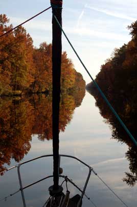
We told Robert we were headed for the Welcome Center and waved goodbye as he opened the bridge for us. Thunk! Before we had even gotten under the bridge, we had hit our first debris. Surveillance photographs later proved that the Captain might have seen those particular debris, but the sun was in his eyes and he was evidently busy taking pictures. During the next eighteen miles, Seaductress took several more hits. So much for all that new paint down on the keel! There was enough water down there--often around eight feet, occasionally the advertised six--but apparently there were a few logs there on the bottom waiting for us. The canal is arrow-straight until you get to the big event ten miles in--a turn of about thirty degrees, then straight again. The ancient remains of boards and logs that lined the banks of the canal poke out on each side. The trees reflect magically in the tannin-soaked, leaf-covered water. Looking ahead through the binoculars at the narrow cut with tall trees on each side, it looks as if you are sailing through an endless canyon.
There was just one other boat at the Welcome Center, the Gulfstar 50 Gone Away with just Capt. Skip and his dog Emma aboard, also headed south. We tied up, ate veggie dogs, and relaxed after a long day in the swamp.
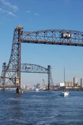
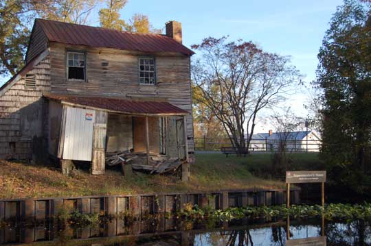
Photos: (1) Lots of bridges near Norfolk. (2) Dismal Canal. (3) Superintendent's Home on the Canal.
November 6, 2006 - Elizabeth City, North Carolina
Twenty three years ago, not long after his wife passed away, Fred Fearing and a buddy of his started organizing wine and cheese welcoming parties to the cruisers who arrived by boat in Elizabeth City. They gave roses to the ladies who arrived and became known as the "Rose Buddies." Later Willard Scott featured their hospitality on the Today Show and provided a golf cart to help deliver the goodies to the pier.
We arrived at the free docks in Elizabeth City and were welcomed by Sam, the dockmaster, who directed us in next to the trawler, Hattie H. We'd followed Hattie and another trawler, Endeavor, down the canal and through the lock at South Mills, which dropped us nine feet back to sea level. As the trawlers sped ahead of us, we were soon alone on the very beautiful Pasquotank River. I felt as if we had somehow gotten our 35 foot sailboat out into the Okefenokee Swamp, the narrow channel of dark water winding around the cypress banks.
After tying up at Elizabeth City we had time to walk around a bit and visit a small playground, then headed for the Rose Buddy party in a tent nearby. Around a dozen boats were at the docks, so at least two dozen of us enjoyed the party along with several of our hosts. Since roses were not in season, each of the girls received a cotton blossom. Elizabeth City certainly lived up to its name as the "Harbor of Hospitality."
Photos: (1) The free docks in Elizabeth City just before the moon came up. (2) Annie after the moon came up. (3) Fred Fearing and two members of his fan club.
November 8, 2006 - Campbell Creek, ICW Mile 155, North Carolina
For the second night in a row we're anchored in an area of sparse cell phone coverage, so I'll write this without being able to upload it.
Yesterday we got up to tour the Museum of the Abermarle in Elizabeth City and found that all the other boats (save Zulu I, who were awaiting prop repairs after hitting debris in the swamp) were long gone. The museum had been described as a huge, empty building, but we enjoyed the exhibits there and felt the experience was well worth the price of admission (free). The weather forecast had probably scared all the other boats away, but I figured that we'd put up the sails and go even faster when the strong southeast winds in the forecast arrived. Rain? We didn't mind rain, I'd said, so long as it meant warm temperatures.
We crossed the open water of Abermarle Sound and headed through the Alligator River Bridge, noting that all the other boats were bailing out into the marina nearby. The sky was getting darker, but we only needed a couple more hours to get down to the end of the river to an anchorage that would shelter us from the southeast. An hour later, our trip to the museum caught up with us as the skies opened. The wind jumped from fifteen to 25 knots in less time than you can say the words. Already dressed in my foul weather gear, I had been contemplating furling the genoa and had contemplated a minute too long. When the winds get to twenty knots, it's almost impossible to furl the genoa by pulling manually on the furling line. At 25 knots, the only recourse is to winch the furling line slowly in while the sail flogs horribly. By the time Annie and I had accomplished this task, the sail twisted so tightly that we actually ran out of furling line, the flapping monster had done considerable damage. The wind indicator on the starboard shroud was gone. The lifeline on that side, repaired with a length of cord, had broken free. Another length of cord was wrapped in knots around the genoa sheet. Worst of all, the sacrificial cloth all along the length of the genoa had been ripped loose of its stitching.
But with fifty miles under the keel we did get anchored in a lee that stopped the waves and spent a fairly peaceful night. In the morning we were underway by 8:30 AM and made another fifty miles to anchor in Campbell Creek, halfway between the Pamlico and Neuse Rivers.
November 9, 2006 - Spooner Creek, North Carolina (ICW Mile 210)
Of course, there are downsides to the cruising life. For example, you might imagine that Annie was not happy when I told her we needed to do major repairs on the genoa, and you'd be right. "I wish this trip was over," Annie said today. We've been doing the same routines on the same little boat for long enough now that sometimes the thrill isn't just gone, it's forgotten. Most of the time now it seems we're just retracing our steps, the girls down below all day reading, me watching the landmarks scroll past the cockpit, not sure whether to be nostalgic or happy to get another milepost behind us. As we slowly sailed past the town of Oriental today, I kept looking at the harbor through the binoculars as if there were something there I needed to see, something I couldn't quite remember but missed just the same.
But there was good news for us today as well. When we anchored here in Spooner Creek on our way north four and a half months ago, we hadn't stopped to check the report of a dinghy dock with shopping centers nearby. In fact, I had imagined the residents of the McMansions lining the creek probably didn't care much for our presence. This time, with four other cruising boats already in the creek, I launched the dinghy and was immediately hailed by a very friendly resident who assured me that the dock and the shopping did exist up at the head of the cove. Sure enough, within a few minutes I was strolling down the aisles of a Super Walmart (some may argue that's not altogether a good thing, but when it's late in the day and you need oil filters and milk, there's an undeniable logic to it).
November 11, 2006 - Wrightsville Beach, North Carolina ( ICW Mile 283)
By dawn all the other boats were gone from Spooners Creek. Cruisers are a strange lot, rising before daylight and then anchoring or going into a marina by early afternoon. Even though we sleep a bit later, we generally have plenty of time to catch up. Still, it was a short day even for us when we pulled off the ICW just south of Camp LeJune at Mile Hammock, a dredged basin created for training Marines but on this night occupied by over twenty cruising boats. The weather was glorious: bare feet and shorts returned to the cockpit.
Today was a bit more of a challenge. Just a mile south of Mile Hammock we faced the New River inlet where we had run hard aground on the trip north. We hadn't heard anyone calling for SeaTow or Towboat U.S. and saw no wreckage, so with fear in our hearts and a rising tide we headed down the monster's throat. Since we had hit bottom last time while following closely to the red nuns, this time I stayed toward the other side where we had gotten through before...proceeding at a cautious speed...only to run aground again as a flotilla of two trawlers and another sailboat bore down pell-mell from behind us! One trawler went right through, the other started wandering all over the place in a very confused fashion, but by this time we had backed off the mud and motored across the center, about fifty feet off the reds, never seeing anything less than ten feet. Apparently this section had been dredged, at least in the center.
Next we faced three restricted bridges, the first and last of which only opened at the top of the hour. Fortunately, we got the timing right and never had to wait more than five or ten minutes. Immediately past the last bridge we pulled into the Wrightsville Beach Marina for fuel, water, and a pumpout. The current can make docking here a challenge. The diesel fill was a huge nozzle that barely fit and made filling our jerry jugs very difficult, even with a funnel. But no sooner had we gotten underway again when we heard the Coast Guard talking a fishing boat out in the Atlantic through giving an unresponsive patient CPR, which put our own difficulties in a different perspective.
Soon we were anchored with around forty other boats in the basin off Wrightsville Beach. Last time we were in a hurry and didn't go ashore, but tonight we took the dinghy in to a nice dock and enjoyed a quick visit to the beach, a great tex-mex dinner (I had my first fish taco and loved it), and some provisioning at a nearby grocery store. I can see why this is a popular stop.
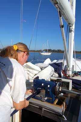
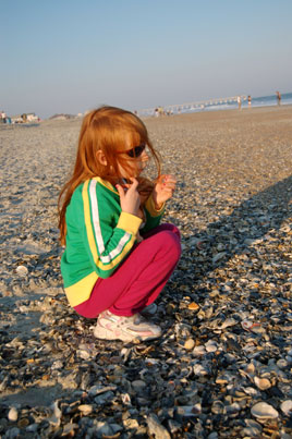
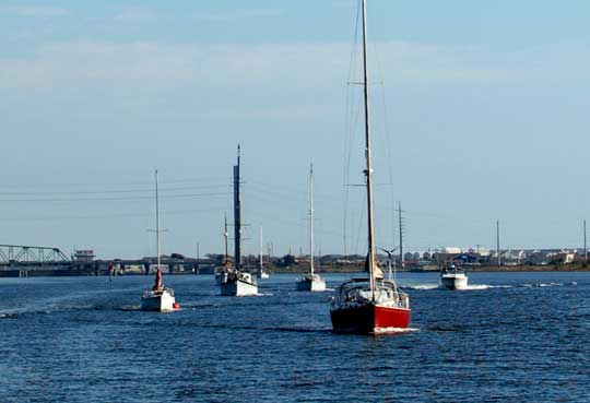
Photos: (1) Annie turned the cockpit into a sew shop at Mile Hammock, fixing our genoa in record time. (2) Laura in Shelltopia at Wrightsville Beach. (3) Soubound morning traffic on the ICW.
November 12, 2006 - Wrightsville Beach, North Carolina ( ICW Mile 283)
It's blowing 20-25 knots out of the northwest as a front moves through, so most of the boats in Wrightsville (including us) are apparently staying put. We are contemplating going out into the Atlantic tomorrow for an overnight down to Charleston if things calm down as forecast. Although the Waccamaw River is very nice (surprisingly different from the retail store of the same name), there isn't much else we really want to revisit on the next stretch of the ICW.
November 14, 2006 - Charleston, South Carolina ( ICW Mile 469)
We are at the docks of the Charleston Maritime Center after a pleasant 26 hour trip down the coast. I had wondered if we would be all alone out on the Atlantic, but quite a few other boats exited the ICW parade route with us yesterday at Cape Fear. We had the lights of Kokopelli, Lunasea, and the beautiful Bayfield ketch Second Wind in sight at all times, but it was our own Seaductress who took line honors into Charleston. Unfortunately, the race was done entirely under engine power since a promised northwest wind was instead a west wind motor-sail. Actually, Second Wind liked the conditions enough that they turned away from the inlet and continued south this morning; clever, but they will be scored a DNF for this round.
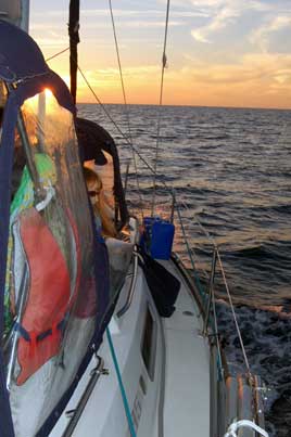
Guidebook guru Skipper Bob argues that the inside route takes no longer than going outside, and when the weather is uncooperative that may be correct. However, when conditions permit an overnight sail there's no contest. It would have taken us three days plus three nights at anchor to motor the 160 miles inside from Cape Fear to Charleston, but instead we motored 120 miles in one day and one night. Offshore we had to deal with small waves and scan the horizon and radar occasionally, but otherwise the autopilot did all the work. There were no shallows to dodge, no bridges to open, no traffic jams. A few miles south of Cape Fear we passed through a dramatic transition, an actual line in the water, between muddy brown water and the beautiful pale blue of the Atlantic. When dolphins came to play we could once again track them underwater, something we haven't been able to do in a long, long time.
Obviously being offshore, even near the coastline, involves a little more risk, especially as the water gets colder with the season and hypothermia enters the equation. As we came into Charleston we threaded our way between rocky jetties that project almost three miles out into the ocean, passing the spot where the Cal 34 Morning Dew sank after hitting the jetty in the darkness of a stormy, cold December morning nine years ago. Everyone on board, four in all, died in the water that night; the NTSB report cited their "failure to adequately asses, prepare for, and respond to the known risks of a journey into the open ocean," but also faulted the Coast Guard's inadequate search and rescue. We motored past red nun #22, where a crewman on a car carrier had heard a doomed voice call for help from the water, and I couldn't help thinking how ridiculously sad it was for people to die there, just a quarter of a mile off the beach, just a few miles from a Coast Guard station. Seaductress is infinitely better-equipped to avoid and deal with this kind of catastrophe, but it doesn't hurt to be remember that there are circumstances that can put any boat under the waves and anyone in the water.
We have a slip here for a couple of nights and have already visited the Harris-Teeter store for sushi and the Imax Theater for popcorn. We also found a nice playground not far away. A strong cold front is forecast to arrive tomorrow night. We're hoping to ride that out here at the dock and then go back offshore on Friday for another overnight trip down to St. Mary's for Thanksgiving.
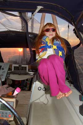
Photos: (1) Looking for dolphins twenty miles off the North Carolina coast. (2) The cockpit, like most of the boat, is a jungle gym for certain members of the crew.
Next Two Weeks | Previous Two Weeks | Start of Log

![]()
Copyright © 2007 by Rodger Ling.
All rights reserved.
