Thursday, May 18 - Marsh Harbour
The sky finally cleared last night, so after waiting for the tide and a quick visit to an excellent grocery in Man-O-War--right on the water with its own dinghy dock--we were able to move to the famous Marsh Harbour. Counting the marinas, there are probably about eighty cruising boats in the harbour here, with twice as many more scattered in the greater metropolitan area that includes Hope Town, Man-O-War, Guana Cay, and Green Turtle. At least twenty boats left today heading north, but there is still quite a community here. Every morning at 8:15 on Channel 68 is an hour-long cruisers net, and although the format is similar to what we heard in Marathon, George Town, and Luperon, somehow this place--thanks to its very friendly and chatty moderators--seems to be the original that the others are trying to imitate.
Looking at all the boats and listening to all the voices every morning, I'm reminded that this cruising lifestyle that we've adopted is hardly something unique. All the folks at home seem to think that we're pioneering our way around the ocean, but in fact there are thousands of people doing the same thing right here in the Bahamas every day. Indeed, listening to a number of boats who are going straight offshore up from here to New England I know that many are far more adventurous than we will ever be.
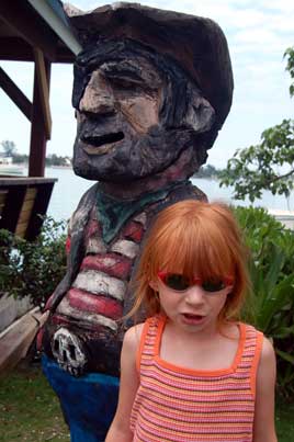
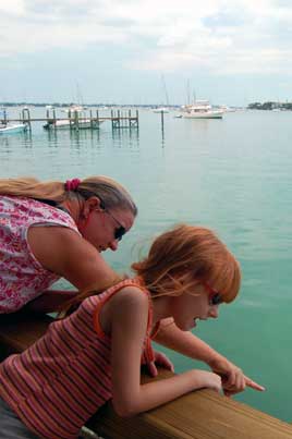
Title Photo: A group of local women at the Iggys souvenir store in Marsh Harbour. Above: (1) Two Marsh Harbour pirates. (2) We may never know what they saw because the water in the harbour is not particularly clear.
Marsh Harbour is a good anchorage with good facilities and that excellent sense of a cruising community. Someone here has gone to some expense to make the place nice, putting sidewalks, flowering plants, and a "rest a while" station with map near the marina. There are bars and restaurants for those with the money to partake in them. Still, I couldn't see us spending more than a few days here. I understand now why Skipper Bob, in his "Bahamas Bound" planning guide, advises first-timers to do the Abacos while just about every other cruiser we met strongly preferred the Exumas. What we've seen of the Abacos so far is far more developed, with lots of opportunities to grab a mooring, duck into a marina or get something fixed...almost like an extended suburb of Florida. There isn't a store equal to Solomons here in Marsh Harbour in all of the Exumas, including George Town--you're much more on your own down there--but for me the raw beauty of the Exumas more than makes up for any lack of creature comforts.
There was no wind so we motored the five miles over here from Man-O-War, and the shaft/cutlass bearing seemed to do okay. I think it's likely we can make it back to Florida, probably Fort Pierce, before doing any major repairs.
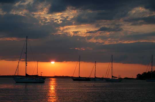
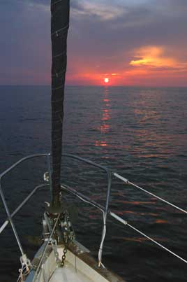
Photo: It was a peaceful sunset over Marsh Harbour. Actually, it was Friday night and there was live music in the distance from one of the restaurants on shore that went on long into the night, so maybe it wasn't really all that peaceful.
Extra! In trying to pick a photograph for the title shot for this two week period, I ended up with a couple of photos that I liked and wanted to use somehow, but doubted that I would ever fit them in. Now, for the first time on public display is my updated collection of title photos I never used.
Saturday, May 20 - Hope Town
We hung out in Marsh Harbour all day yesterday, doing a little shopping and taking Laura to her favorite restaurant (Subway) for lunch. I called Harbortown Marina in Fort Pierce, Florida and made a date with a travel-lift. We now have a 12:30 PM appointment for Thursday, June 1st to have our cutlass bearing replaced.
We left Marsh Harbour this morning and motored around the point to go snorkeling at Mermaid Reef. Actually, we anchored about a mile away in some grassy sand after seeing hard bottom closer in, but of course when we actually got into the water we found plenty of good anchoring sand right next to the reef. The snorkeling was good with lots of fish and the reef is very accessible since it's right off a beach. Visibility was about 25 feet, which is fantastic by Tennessee standards but not quite as good as we got used to in the Exumas and Far Out Islands.
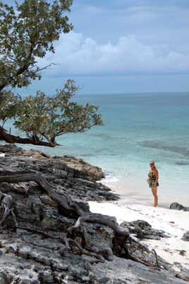
After lunch we motored into Hope Town on the rising tide just to have a look around, intended to anchor elsewhere, but the town looked so inviting that we picked up a mooring ($20/night from Hope Town Marina) and stayed put. The high point of our afternoon in Hope Town was, of course, the lighthouse--it's 120 feet above sea level, after all--one of the last kerosene-burning manually operated lighthouses still in operation. However, the narrow lanes between colorful rental cottages, the beautiful beach on the Atlantic side, the playground with its shaded teeter-totter, not to mention the free wireless Internet in the harbour (maybe that $20 plays into this), makes Hope Town a very nice place to spend a day or two.
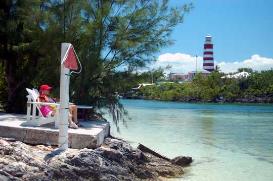
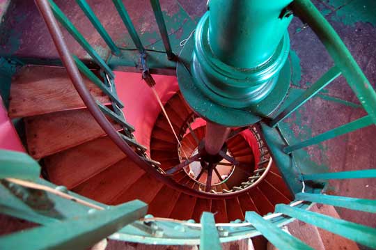
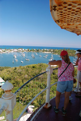
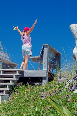
Title Photo: (1) Annie and Laura relax after negotiating the shallow entrance channel (in background) to Hope Town. (2) The Elbow Cay Lighthouse at Hope Town has 91 steps, most of which are shown here. (3) The view of the harbour from the top made us all thirsty. (4) Summit! Balboa Annie reaches the top of the dune and sees the Atlantic Ocean.
Thanks to the improved Internet access, we were finally able to check the old rling@stationr.org e-mail address properly for the first time since Luperon and were very pleased to see we had previously undetected mail from several friends, including Godwin on Bonjangles and our beloved friends Janet, Rhonda and Tye the Cat on Promise. We were amazed to know that Promise just left the Abacos a couple of weeks ago. If we'd known we were that close, we would have tried to get here sooner, but we hope to see them again when we go up the east coast.
Sunday, May 21 - Guana Cay
Before lunch we returned to the nice beach on the Atlantic side of Hope Town for snorkeling and sand-surfing. To do the latter, you lie down in the surf and let your bathing suit, pockets, and ears fill up with sand as the waves push you up the beach. This, of course, was Laura's favorite activity. There were some nice reefs just thirty feet from shore. Although Annie was not as impressed, I agreed with the guidebook that Hope Town was among the most picturesque settlements in the Bahamas, even if it could hardly have any full-time residents since every home you see is a pretty little rental cottage. Where do the local people live?
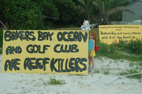
We listened to a bit of drama on the VHF as we were preparing to leave the harbour. A sailboat had gone up on the reef at the South Man-O-War inlet, and seemed a little clueless about what to do. Perhaps it was a language barrier, but more likely they really didn't know. The local BASRA volunteers eventually started trying to find someone to help pull them off on the rising tide, but eventually a passing boat took pity and freed them. There was no word of a boat sinking, so perhaps no lasting harm was done. In the meantime we motored about ten miles from Hope Town to Fishers Bay at Guana Cay, where we anchored in the company of no less than thirty other boats. We dinghied ashore to the very posh Blue Water Grill and spent some time talking with the owner, Edmund, who was later described to us as being the unofficial mayor of the Cay. The Grill was the first place we started seeing "No Golf on Guana!" signs, and these grew ever more numerous after we dinghied over to the Guana Beach Resort to get a little closer to town. Apparently the "Discovery Land Company" is planning marina and golf course to the north at Baker's Bay, which was once a cruise ship playground. "Why give a billion dollar developer exemption from taxes for 20 years?" a big sign says at the harbour, while another says, "Crown Land for Bahamians." Apparently golf is not all that popular on Guana Cay, particularly with the reefs that may have to face the run-off.
A couple we met on the dock had described the beach bar Nippers as a "fraternity party," and they were quite right. Bright pastels, swimming pools, dance music, guys half passed out on the beach below: this was Nippers, the party headquarters of this entire area. Apparently the reminder that "the wages of sin are death" sign at the cemetery on the path to Nippers is quickly forgotten. I have to wonder if the anti-golf course signs will be any more effective.
Poscript: Later I was able to visit the website of the Discovery Land Company and view what is one of the most comically horrific mission statements I have ever seen:
Inspired by the historic journey of Lewis & Clark's Corps of Discovery, we view our mission as one of exploration.
Our objective is to seek out new lands and new opportunities in uniquely beautiful locations where we may explore and create truly exceptional golf communities.
I honestly don't know whether to laugh or to cry when I read that. Apparently the residents of Great Guana are still fighting the development in court, although the past history of the Bahamas, where entire islands are sold to cruise ship companies, doesn't bode well for them (see Eco-Friendly Development Set To Resume). There is apparently a similar fight between the traditional and tourist economies taking place on the Cat Island, where a resort/casino is planned for the Atlantic shores. For more info on Bakers Bay, see Little Gidding's log and the Save Guana Cay Foundation's site, plus, of course, the aforementioned Discovery Land Company site.
Title Photo: (1) I advise against walking around town with your golf bag over your shoulder. (2) The view of the beach at Nippers probably looks even better when you're drunk. (3) I've heard of clothing optional, but at the Guana Beach Resort it's actually a rule.
Monday, May 22 - Green Turtle Cay
Another typical morning in the Abacos: sleep late, listen to Patty on the cruiser's net at 8:15, putter around and eventually get underway. "It's lucky that we aren't having to sail through the Abacos," Annie said, and I had to agree. There just hasn't been much wind to get us moving, especially without a spinnaker. Fortunately, we are able to motor normally at most RPM's.
Today we negotiated the treacherous Whale Passage (certain death in the wrong conditions, ridiculously easy when there is no swell breaking as we had today) and anchored just off the harbour at Green Turtle Cay. We were most impressed by the dinghy dock, the pretty little town, the Blue Bee Bar, and especially the memorial sculpture garden with its bronze statues of settlers and citizens. The centerpiece of the garden is a life sized statue of two women, one white and one black, landing on a Bahamian beach. It was hot enough that we had to stop two or three times for ice cream before we got back to the boat.
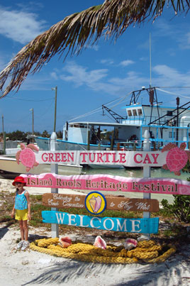
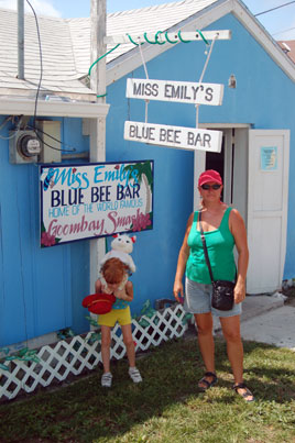
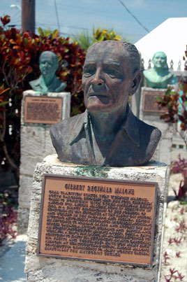
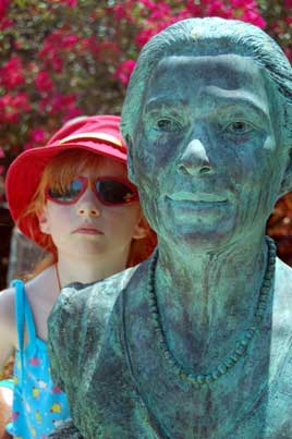
Photos: (1) The town of New Plymouth on Green Turtle Cay is very welcoming, with the best dinghy dock we've seen yet. (2) The Goombay Smash was invented at Miss Emily's Blue Bee Bar, but alas, we ordered Ginger Ale. (3) The heads and biographies at the Memorial Garden were amazing in their simplicity and dignity. (4) We all make history if we're careful enough to see it.
Ship's Note: I added ten gallons of diesel to the tank (574 engine hours), then refilled the jerry jugs at Green Turtle Cay Marina. We're now fueled to make it to Florida.
Tuesday, May 23 - Manjack Cay
We attempted to visit the environmental museum in New Plymouth this morning, having been unable to do so yesterday because they closed at 1:00 PM. Today we read the sign again more carefully and found they are only open Mondays, Wednesdays, Fridays and Saturdays. However, we did get some more delicious home-made ice cream at Lowe's Grocery before motoring just a few miles to Manjack Cay. This is not a place I would expect to get wireless Internet (we never could get it to work with all the marinas around Green Turtle) but I've got a good signal here from some helpful resident.
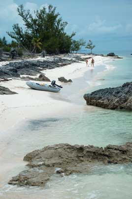
Now it's a few hours later, and we've returned from a dinghy trip around the southern tip of the island to the Atlantic beaches. In the shallow water between Manjack and Crab Cays we saw jellyfish, sea stars, and two sea turtles. Some of the guidebooks mentioned a dock leading to a nature trail through the mangroves, but the pier was wrecked and no path could be seen. However, the beaches on the Atlantic side were both beautiful and majestic, with lots of rocks and some decent snorkeling just off the beach. Although there are more than a dozen boats in the anchorage with us tonight, there is more than enough deserted beach to go around. Despite our first impressions of islands that are overdeveloped, the Abacos do have their charms.
(Editor's Note: We had noticed a nice beach and house near our anchorage at Manjack and I had purposefully kept my distance, thinking the last thing the residents wanted was cruisers cluttering their beach. Actually, I've since heard they are former cruisers themselves and welcome visits ashore, with a hammock and slide and other goodies. Apparently even the Internet access in the harbor is no accident.)
Photos: (1) Another one of my favorite beaches. (2) The rocks and trees on Manjack's beach are friendly and let you get as close as you like.
Wednesday, May 24 - Powell Cay
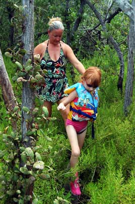
A quick ten mile motor jaunt, and we were soon anchored at Powell Cay. We checked with the Catalina 40 Contented anchored nearby and were told there were two trails off the northern beach, one to an overlook and the other across to the Atlantic side, so off we went into the jungle. I would officially designate the trail across the island as the "Poisonwood Trail," because that noxious tree was extremely common along the path. Poisonwood is a five-leaved small tree (although there is a quite large one near Nippers on Guana Cay) similar to the poison ivy we have in Tennessee. The horror! Had I known, I would not have attempted the trail, although the deserted beach on the other side was nice. Our only hope was to plunge into the surf on the Atlantic side. Laura especially enjoyed playing in the enthusiastic waves.
Back at the dinghy, we washed off again and then went snorkeling for good measure. Although the visibility wasn't great (about twenty feet), there were plenty of fish including sea stars and two lobster along a cliff between two beaches. We retreated to the boat in late afternoon for a nap.
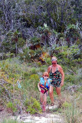
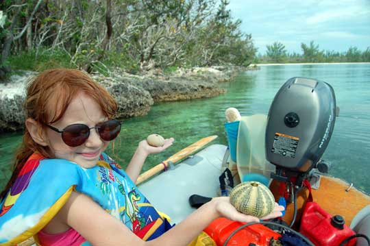
Photos: (1) The boardwalk near the Atlantic beach on Powell Cay. (2) Intrepid explorers emerge from the jungle at Powell Cay, headed for the ocean. (3) Sea urchin shells found while snorkeling the shore near the anchorage.
Thursday, May 25 - Allans Cay
Another dozen miles closer to Florida, we anchored at Allans-Pensacola Cay with six other boats, most of which are motor vessels. As we get closer to Florida and the sailing season winds down, we're seeing and fewer sailboats and more powerboats. Last spring in the Exumas, a motor vessel was a rare sight.
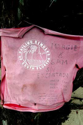
We dinghied towards the head of the anchorage bay and then hiked a marked trail towards the Atlantic side. The trail is the remains of an old road that used to lead to a U.S. missile tracking station, but if there are any significant ruins they are hard to see in all the growth. There was some poisonwood on this trail but it was easily avoided and someone had marked the most obnoxious specimen with a little sign that said, "Poisonwood: like poison ivy, but worse!" Cruisers have left lots of memorabilia on hanging from the "memory trees" on the beach, generally old floats, bottles, and driftwood, but there was a spatula and even the front cowling of a car hanging there as well. It was fun to see a T-shirt labeled "Florida Sailing Singles" from our friends Sam and Margie on Encantada documenting five years of Abacos cruising.
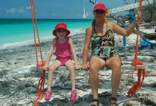
Photo: In the midst of all the graffiti-like hanging debris, someone had actually hung up something useful: a neat little swing. In the background you can also see a spatula. Later when Annie wouldn't let me use her spatula for scraping barnacles off the boat, I contemplated going back for this one.
Friday, May 26 - Great Sale Cay
After listening to the Chris Parker Early Show, I hoisted both the sail and anchor and by 7:00 AM we were silently leaving the anchorage at Allans Cay. We made good time sailing for ten miles or so, but since we needed to charge the batteries and make water anyway, we fired up the iron horse for the last twenty miles to Great Sale Cay. Since the wind was from the southeast, we anchored on the west side rather than in the traditional harbour on the south side. The only inhabitants of the island, aside from passing cruisers, seem to be diving ducks, but we did find the ruins of what looked like another abandoned missile tracking station (did every island in the Abacos have one of these?). Thunderstorms were all around, including one with a waterspout, but fortunately none came our way. It is a sort of bittersweet night, our last night in the Bahamas, with lots of memories of places, friends, and happenings.
We talked for a while with Rich and Chris on the Tartan 3800 Tardis, who are heading for Fort Pierce around 11:00 tomorrow morning. That sounded good to us. By evening we should be moving off the banks into the Florida Straits, arriving at the Fort Pierce inlet around 8:00 AM. There probably won't be much wind, but if the old girl can motor this far, she ought to be able to get us home.
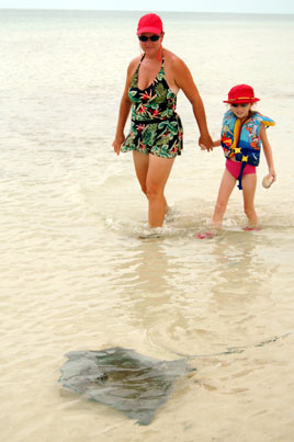
Photos: (1) This stingray was actually quite friendly, shaking his tail at us several times as we approached. (2) Already we are living in the past: this photo is actually from yesterday. Margie and Sam made a lot of trips to these islands.
Sunday, May 28 - Fort Pierce, Florida
We left Great Sale at noon yesterday and still in the company of the yacht Tardis arrived at the Fort Pierce inlet around 7:00 AM after an uneventful crossing, all but two hours of it under power. Seas were very light, winds not quite on the nose most of the way, with brightly lit cruise ships coming and going. We caught five fish in under two hours, but threw all of them back. Four were big barracuda and one looked like an immature tuna. The sixth fish must've been very large because he broke the line and the shock cord when he hit. That Triple-D lure I got from Don on Warrior was very popular right up to the end.
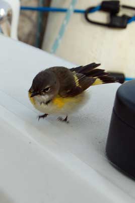
Later, I was sitting in the cockpit when a small fluffy bird (a first year male American redstart as I found out later from Robert Smith) landed on my shoulder. The closest land was 25 miles at West End so he had flown some distance. The obviously tired bird explored the entire boat, from the dinghy in the davits to the bow, then hopped below and toured every cabin before settling down for a nap on the nav station counter. He was completely oblivious to our presence and also fairly oblivious to the sugar, fruit, and water we tried to put out in front of him. Sometime in the early morning hours I noticed he was gone from the nav station so we can only assume he jumped ship.
While Tardis headed up the ICW to Vero Beach, we checked out a shallow anchorage in front of Harbortown Marina but then decided to go in and get a slip. The marina has a pay phone for calling U.S. Customs and advises grabbing a chair because it often takes a while. For me, thanks to a fellow cruiser who was able to hand me the phone after he had finished, it only took about a half hour. However, for reasons that no one I have asked has been able to tell me, all of us on the boat still have to go out to the airport and check in personally. If someone can tell me a scenario in which this procedure could actually help enhance national security, please do so and I will gladly give you a dollar.
Coming into the inlet was culture shock for me. So many boats, lights, high-rise buildings, and commotion! I feel like we're suddenly in Las Vegas. For the moment, I think I'll sleep for a while before wading back into the rush of America on a holiday weekend.
Photos: (1) I worry about our little bird friend. (2) Sunset over the banks as we leave the Bahamas. Florida is only about 60 miles across the water at this point.
Monday, May 29 - Fort Pierce, Florida
Jeeper's, it's hot here in Florida.
Tuesday, May 30 - Fort Pierce, Florida
We've decided to take it easy and stay here at the dock for now. Harbortown is an amazing marina, very clean and professional with staff working constantly to keep the customers happy [update: see Dec 14 log for a very different experience on our next visit]. I checked in with Indian River Boatworks and confirmed we're on the schedule to haul out at 12:30 PM on Thursday. Yesterday we visited Big Box Mart (please see www.jibjab.com if you haven't already viewed their satire on this new American tradition). Today we went to a Verizon store and got a more modern calling plan for our cell phones, so if you want to call us on nights or weekends we can talk as long as you like.
Current plans are to meet Krissy and Robert at St. Mary's on June 10 and (weather and boat repairs permitting) anchor overnight at Cumberland Island.
Next Two Weeks | Previous Two Weeks | Start of Log


Copyright © 2007 by Rodger Ling.
All rights reserved.
