March 22, 2007 - Normans Cay
At midnight I was up in the cockpit dressed in my foul weather gear, zipped up and waiting for the big storm that had been threatening for the past hour. In the distance, the lightning was almost continuous; I watched and waited as the winds started gusting up past 25 knots. I waited, and waited, and nothing ever came, so I went to bed. I heard this morning, however, that squalls blew 60 knots in George Town.
Today we sailed up to Highborne, spent $186 on food, water, and $65 on fuel (18 gallons)...just another routine day, except for the expense. It's easy to dop $300 on Highborne. We did catch a fish, a yellowtail snapper, while coming back (the secret is to troll right over the coral without ramming the reef with your keel, which might scare the fish) but this specimen was only eight inches long so we let him go. Okay, actually he got off on his own, saving me the trouble.
We're anchored now on the inside at Normans Cay, with Laura over on Magic playing with Samantha. The forecast shows a possibility of a window to cross back to Florida next week, so in the meantime we will spend some time exploring this classic cruising destination.
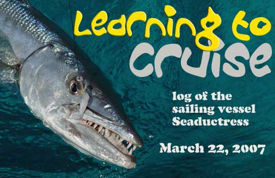
Title Photo: I've heard some people eat Great Barracuda, but there's not much meat left once you remove the teeth. Photo by my sister Krissy, the award winning animal photographer. Click for more of those tedious alternate title shots.
March 24, 2007 - Normans Cay
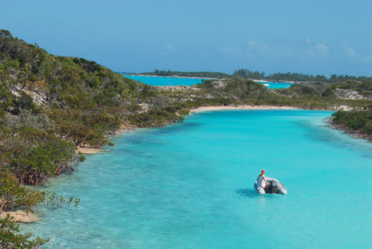
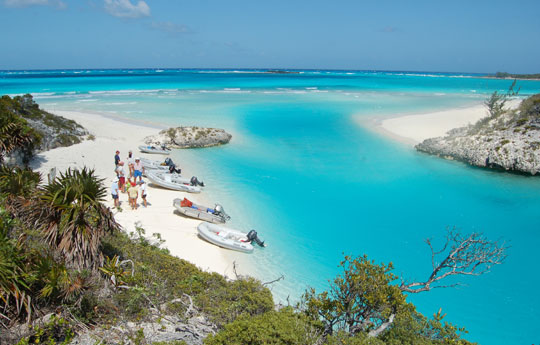
Yesterday we explored a good bit of Normans Cay. In the morning I took the dinghy up through the shallow water to Normans Pond, a wonderful calm lake of clear water that was providing a refuge for two sailboats and a trawler. Unfortunately, when I scouted the entrance from Exuma Sound I found not much more than four or five feet of water; although the route did not look particularly difficult, we would need a very high tide to get in or out. later Annie and Laura joined me to explore the ruins of the Normans Cay Club at the south end of the island. Someone has repaired the dock and removed several old trailers, but the buildings are all still ruins.
Normans, of course, is famous for being the center of a cocaine smuggling operation during the late 1970's and early 80's. Nasty things went on here; we found what we thought might be bullet holes in one of the buildings. The sunken C-46 drug plane in the inner anchorage is the most obvious legacy of those days. Last year we never came close enough for a good look and saw only a small hump of metal sticking out of the water, but this time I stuck my face in to see that much of the huge airplane is intact below the water and now home to lots of fish. It's well worth snorkeling although I keep hearing rumors that sharks like it, too.
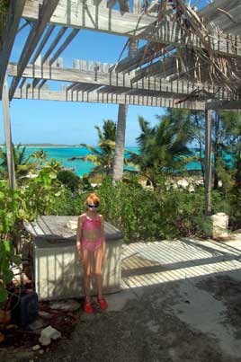
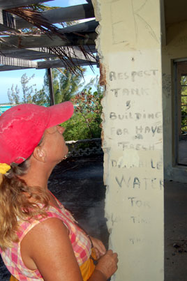
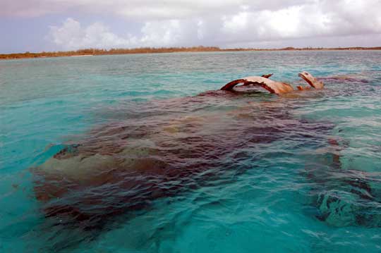
Photos: (1) Many cruisers get water for washing or laundry from the old cistern (the opening is under the plywood square next to Laura) at the old Normans Cay Club. (2) The sign advises, "Respect tank and building for have fresh drinkable water for long time." (3) The crashed plane at the Normans Cut anchorage.
We spent one night in the cut, then moved last night to the west side of the island. Despite being only a hundred yards off the beach, some kind of wind chop or short swell rocked us all night. Today we moved back to the inner anchorage. It's no calmer here, but more central. Magic was going to organize a bonfire on the beach tonight but the winds just won't allow it. Except for very brief periods, the wind has blown 20 knots out of the northeast for at least ten days straight. There are dozens of boats waiting here in the northern Exumas for a window (said to be coming next week) to cross back to Florida, and the marinas in Nassau are rumored to be full as well.
March 26, 2007 - Shroud Cay
 We spent yesterday hunkered down on the boat in Normans Cut, except for a singular outing with the crew of Magic to the tiny "Helen's Island" in Norman's Cut. This tropical getaway is about fifty feet wide by two hundred feet long, with a single palm tree topping it's highest point. The girls snorkeled in the shallow water adjacent to the island while I kept a eye out for a shark I had seen there the day before. This time, since the folks from Calypso Poet and Barefoot Shoe were no longer cleaning fish there, the shark did not make an appearance. We had dinner aboard Magic so that we could help Victoria with her computer, but of course failed to get around that task. As it has for the past two weeks, the wind was howling and the current was racing through the anchorage. Fortunately, the wind was strong enough to keep the boat pointed into the wind despite the current, and there being plenty of room to swing if necessary we rode just fine on one anchor.
Today we sailed the few miles back down to Shroud while Magic made an attempt at reaching the store at Highborne. They were turned back by waves and wind and ended up in their old spot at Normans. We, in contrast, got a much more settled spot on a mooring here at Shroud and enjoyed another dinghy trip up the creek this afternoon. We took the southern creek just north of the anchorage in, and returned by the deeper northern creek. Unless you are close to high tide, the southern creek can get uncomfortably shallow.
Our current plan, subject to the inevitable changes due to weather, is to get up to the Nassau area on Wednesday, then depart in the morning for the 160 mile overnight sail to Miami.
Photos: (1) This is how Annie would look driving the dinghy up the northern creek on Shroud, if Laura and I were to get off and climb some rocks to photograph her. (2) And here, once again, is everyone's favorite Shroud creek destination: the creek meets Exuma Sound near Camp Driftwood on Shroud Cay.
March 28, 2007 - West Bay near Nassau
We are on schedule after moving up to Highborne Cay yesterday, then moving forty miles further today to West Bay. Two amazing events happened today: first, we turned off the engine and actually sailed much of the distance. Typically in the Exumas we were never going far enough to finish charging the batteries even when the wind was cooperating. And cooperate it did today, which was the second amazing event. For the first time in weeks, we didn't have to reef either sail because the wind actually dropped below 20 knots.
I had been a little worried about surge coming into West Bay, but talked this morning on the SSB with Cliff on Cliff's Notes. They were at Chub this morning but had been at West Bay a couple of nights ago and said it was fine. Indeed, it is very pleasant here. After anchoring I spent some time getting the boat ready for tomorrow's overnight to Miami:
- Remove engine from dinghy and store on rail to ease the strain on the davits. Some might say you should put the dinghy on the foredeck (the Walker Bay is there on our boat) or deflate and store it below, but our davits are high enough off the water that we are usually fine. Our dinghy is our life raft, so I'm not about to deflate it.
- Double-check the cotter pins on the shrouds. You don't want to be worrying about a shroud coming loose in the dark. We actually had that happen last year as we neared Mayaguana. I was down below trying to sleep and heard a weird banging; the lower shroud had unscrewed the turnbuckle and was actually flopping around. Although our friend Tom Pride would say that's just the sort of thing that happens around Mayaguana, I learned a good lesson about sailing without the cotter pins in place. Why, you ask, would you ever do that? It's because you are intending to adjust the tension in the shrouds...the key word being "intending."
- I used the contents of one of our jerry jugs to top off the fuel tank. We once listened to a cruiser who was trying to add fuel in this way during the night in fair-sized seas and decided that was another practice to be avoided.
- When we pull the anchor tomorrow I'll take a length of cord and tie both anchors down to their rollers. For an ocean crossing, you'd actually store the anchors elsewhere, but I just want to be sure they don't come loose in the middle of the night.
- It's always good to check that all your running lights are working properly. Maybe I'll remember to do that.
- We'll check the abandon-ship bag and lash it in place behind the dodger where it can be grabbed quickly in an emergency. Although it's not as crucial down here as it was in the chilling waters up the east coast, I also like to pack our wetsuits, just in case.
- I like to pump the bilge dry so it will be more obvious if there's a problem there. This also keeps water from sloshing over the keel bolts and causing rust. While we're down there, I'll clean the bilge pump strainers and make sure all are operating properly.
- I'll put on a scopolamine patch before going to bed to help prevent seasickness. The patch needs to be in place at least four hours before departure and is good for up to four days.
- I'll try to update the website (using Globalstar, which will no doubt be incredibly frustrating) so our last known location is officially listed here. By the way, if there is ever an emergency and you are looking for us, Chris Parker of the Caribbean Weather Center can put out a "boat watch" that will be your best bet.
- The engine gets a special look this evening so we're ready to go early in the morning. I'll listen to Chris Parker at 6:30 AM and we'll pull anchor soon after.
March 29, 11:32 PM - Great Bahama Banks approaching Cat Cay
Almost a full moon tonight on the Banks as I write this from the cockpit, the clouds sailing over us while we sail under them. The boat is in a horse race with two foot waves that chase and inevitably catch us, giving off murmurs of victory as they break beside us. When I look straight up, the moon appears in a circular window of cloud that makes it seem as if I'm in a gigantic domed chamber, the clouds impossibly high, the moon higher still. Stars shine through the clear spaces, hundreds of light years distant yet still very close by galactic standards. Looking up again now the mainsail reminds me of the wing of my hang glider wheeling around and around with the sun just off its tip, a golden afternoon spent alone with the clouds.
So this is sailing! We left West Bay at 7:30 this morning and have used the engine really only to keep the batteries charged, sailing along for hours with the wind at our backs.
Photo: We spent all afternoon wing-and-wing, racing over the Great Bahamas Bank.
March 30 - Miami
It seems as if one minute you're in quiet island anchorage in the Exumas, looking at the water in the moonlight, and the next you're in a Miami marina with a Hardrock Cafe, a food court, and an entire mall a hundred feet off your bow.
We had a fine time yesterday until we reached the edge of the Great Bahamas Bank. Most of this particular bank is fine for sailing at night, but at each end there are important obstacles to be avoided, such as reefs and islands. Unfortunately, the alignment seems to be a bit off in our radar, since it was painting big blobs directly in our path, even as I followed the track we had sailed coming the other direction in January. The opening into the banks at Triangle Rocks, just south of Bimini, is a half mile across, but still those blobs vexed me. I did many a scan with the binoculars across the weirdly glowing landscape, ducking downstairs several times to check our track on the laptop and independent GPS running Mapquest charts. We were exactly where we should have been, and as the blobs parted on the screen to allow our passage, I breathed a sigh of relief.
Alas, the forty mile run from Bimini to Miami was not as much fun as the earlier part of the trip. We had been expecting some wind chop from the east, but hadn't counted on it fighting with a swell from the northeast that was running five to six feet. Our course put 17 knots of wind directly astern, which meant the sails didn't do much to steady the boat. As we got further out into the open water, the boat started to roll and slew back and forth in the growing seas. Twice the autopilot was overwhelmed and we suffered dramatic, crashing gibes. We rolled the main in and reluctantly started running the engine at low RPM, leaving just a bit of genoa out to do most of the pulling. I don't think anyone got much sleep last night; at best, I got 45 minutes.
We came in Government Cut at around 10:00 this morning after 26 1/2 hours and roughly 150 miles. Both Dinner Cay Marina and Miamarina had space for us, and I was tired enough to choose Miamarina simply because it was right there at the end of the channel. Since Claiborne Young, one of the cruising guide greats, had counseled against spending the night here without giving any clues why, I was definitely curious what we would find. So far this seems like a decent facility, the only doubts about it being the noise level (tonight is Friday and the parties going on around us remind me of the weekend we spent just down the way at No Name Harbor) and a potential lack of security since the marina is open to the Bayside Mall nearby.
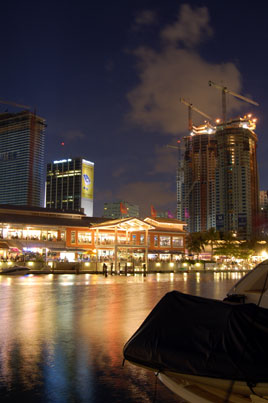
Photos: (1) You could throw a rock from the marina and break a window at the Bayside indoor-outdoor mall. I'm not saying that you'd want to, but that's how close they are. (2) The view of the Mall from near our slip at Miamarina. It seems that all of downtown Miami is under construction.
Perhaps it was the exhaustion, but we just couldn't seem to do anything right today. I was able to call Customs and check in using my cell phone, despite not having my current decal number, then we still had to go visit them in person with our passports. We tried to rent a car from Enterprise, but they had none available, so we called a cab, then spent 45 minutes starving and waiting for the cab to show up at the marina, not knowing that a hundred yards away at the yet-unexplored Bayside Mall were a half dozens cabs sitting there, not to mention an extensive food court. Duh!
Meanwhile the Enterprise guy called back to say he'd gotten us a car, so when the cab finally came we went to Enterprise. The only car available was an SUV for $89/day, so we waited another 45 minutes because a cheaper car was expected to come in any minute. While waiting, we discovered that Miami has free mass transit devices called the Metromover (small automated trains that run on "guidepath" high above the streets that would have gotten us there far easier). Finally we gave up on Enterprise, got a cab down to the Customs and Border Control office at the Seaport where the cruise ships dock to clear in, then caught another cab back to Bayside. While riding back, I realized we could have walked the distance over the bridge to Customs (the north side has a sidewalk) and been done hours before without spending a dime. Now even more exhausted, we rode around on the Metromover trying to find a Publix store, but came back empty-handed (except for learning the location of Hooters in the Mall, which is not something I'm sure Annie really wanted me to know).
I have come to believe that transportation, like information, really wants to be free. In this light, I was impressed with the Metromover, a free above-ground version of a subway. The tracks sometimes look like you're riding a rollercoaster. The stations over the Miami River are around seven stories in the air.
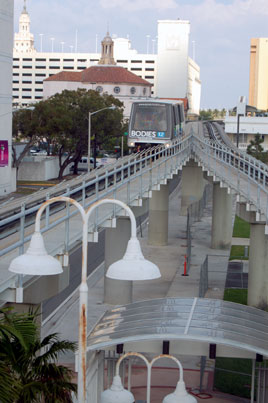
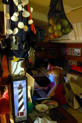
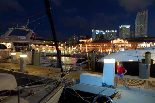
Photos: (1) The Peoplemover lives! Here in Miami it's called the Metromover. (2) Laura in her customary position at the computer. (3) Timed exposure of Laura on the dock with the Bayside Mall in the background. They often have live concerts there, which can be a good thing or bad.
April 1 - No Name Harbor, Biscayne Bay
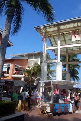
Having paid our dues Friday, were in the groove all day yesterday. Lunch was pizza and falafels at the food court. We rode the Metromover down to 8th Street, walked two blocks further on 7th Street than we had the day before, and arrived successfully at a Publix supermarket. Taking a cab back would have been no challenge, so we hoofed it back to the boat the same way. Laura and I did some shopping. What an amazing place. Being in Miami almost feels more like being in a foreign country than the Bahamas. The colors, the cultures, the Spanish being spoken everywhere--it all combines to make other cities look boring.
I'm still not sure why Claiborne Young dislikes Miamarina, although it's possible that the music that goes until 3:30 AM isn't to his liking. Since we are already acclimated to the howl of the wind and slapping waves all night, it all seems rather peaceful to me. Guidebook author Feya Rauscher gives Miamarina high marks, and evidently so did Sonny Crockett on Miami Vice. This is the marina where he kept his sailboat--yes, the one with the alligator named Elvis aboard.
This afternoon we started down Biscayne Bay and decided to revisit No Name Harbor, our last port three months ago. Where else would you go on April Fools Day? I figured Laura would enjoy a trip to the playground. Even better, not far from the harbor an Island Packet started waving madly at us. It was Chuck and Allie on Kairos, last seen in Vero Beach! It's amazing who you'll meet here.
Ya gotta love Miami.
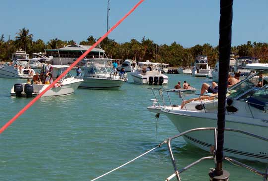
Photo: Just a typical weekend afternoon at No Name Harbor. Believe it or not, the boat just in front of our bow is at anchor, right over our anchor. You really must leave someone on the boat at all times to keep on eye on things, or who knows what will happen.
April 3 - Lower Matecumbe Key
We left Noname yesterday and sailed about 15 miles south in Biscayne Bay to Elliott Key for the night. We had origionally planned to go outside in the Hawk Channel since the chart showed only four feet of water at the entrance to Angelfish Creek, the next crossover point between the "inside" and the "outside." Chuck on Kairos assured us we could go further south in the Bay and make our exit at Angelfish Creek, so off we went. Once anchored about a quarter mile off Elliott we dinghied in to the Park Service docks and hiked the nature trail. Later I dropped off the girls at the boat and took the dinghy about four miles north to Boca Chita Key, which like Elliott has a harbor with camping spots for boaters. While Elliott Key is heavily wooded, Boca Chita is all cleared and somewhat landscaped with palm trees and what turned out to be an "ornamental" lighthouse built in the 1930's.
This morning we hit Angelfish Creek on the tail end of the rising tide and never saw less than seven feet of water, just as Chuck had predicted. It was a fine day for sailing down the keys, and sail we did. We had planned to stop at Rodriguez Key but it didn't look good in the easterly seas so we pushed on to Channel 5, a high-rise bridge that allowed us to cross back over to the Florida Bay side, where we anchored just off Lower Matecumbe.
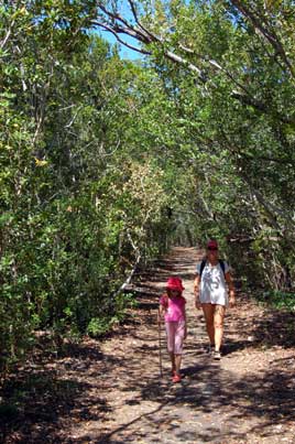
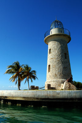
Photos: (1) Hiking what's left of the "Spite Highway" on Elliott Key. In 1968, angry developers bulldozed a 150 foot wide swath down the middle of the island just days before the land was preserved by legislation. (2) The lighthouse on Boca Chita is quite striking, even though it was built in the 1930's purely for decoration. By the way, there are no Boca veggie burgers on the island that I could see...although the Park Service provides grills, so perhaps there were Bocas there at one time.
Next Two Weeks | Previous Two Weeks | Start of Log

![]()
Copyright © 2007 by Rodger Ling.
All rights reserved.
