Next Two Weeks | Previous Two Weeks | Start of Log
Note to Myself
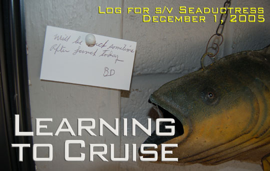
I'm changing the title of this log from "Long Weekend" to "Learning to Cruise," which is probably a more accurate description of our journey. For me, it's not simply a matter of figuring out how to navigate and properly negotiate the water, but also the lifestyle, too. Like the instant-gratification junkies we are, we have to learn how to go slower, worry less, and enjoy more.
Thursday, December 1, 2005 - Mobile
Tomorrow, if we can muster the courage, we will depart Dog River Marina where we have been tied comfortably for the past four days. We rented a car on the first day here and drove over to Bay St. Louis, Mississippi to visit Annie's mother and sister, both of whom are living in FEMA trailers since their houses were flooded and badly damaged by Hurricane Katrina. Yesterday, Annie's sisters came and visited with their husbands and we had a fine dinner across the river at the Grand Mariner.
We had originally planned to leave today but there was just too much work to be done, and as usual I had done very little of it. I climbed the mast to straighten the antenna and examine the anchor light following its meeting with the bridge on Thanksgiving (the bulb was broken and the housing pushed over, but on the whole it could have been worse). I changed the engine and transmission oil, finally installed a ground wire on the new seacock in the aft locker, and smeared silicone and 5200 around in various places trying to make the locker less likely to leak into the living spaces of the boat. Steve and Jerry (the latter had arrived a couple of days ago on his Island Packet) had rented a crane and I tried to help them as they put their masts back up where they belonged. Finally Annie, Laura and I jumped in the courtesy car for a trip to West Marine and Walmart, both of which I had just visited the previous day while returning the rental car. I found out that Annie really goes wild in West Marine, and Walmart wasn't much better as she was seen purchasing four huge boxes of Cheese-its.
Reading Skipper Bob and Claiborne Young's advice and looking at charts has convinced me that it is impossible to go further and we ought to stay right here in Mobile, but the weather just isn't warm enough for that. We will shoot for a day on protected waters to reach Ingram Bayou tomorrow, but then will need to go out into the Gulf to get further east. There are a whole slew of 50 foot fixed bridges on the Intracoastal Waterway, and as faithful readers will know, I am more than a little paranoid about bridges at this point.
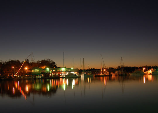
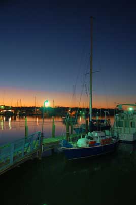
Photos:(1) View of the Grand Mariner Docks. (2) Stap Isi in the sunset. (3) Dog River (and Turner Marine, next door) are busy rebuilding after Katrina.
Friday, December 2 - Imgram Bayou
After some quick lessons in docking (we had moved the boat from the fuel dock the day before and had to move it back to pump out) we departed from Dog River at High Noon, the exact moment of low tide. We briefly touched the muddy bottom of the Dog River Channel in one spot but the rest of the way was plenty deep. We were excited to be underway again and actually hoisted the sails as we cut across the bottom corner of Mobile Bay. As the wind slackened and our speed lessened, we suddenly realized that we weren't going to make it to our intended destination, Ingram Bayou, before dark. Good thing we didn't make these calculations earlier or we might never have left.
Indeed, it was getting quite dark as we entered the "Alabama Cut" of the Intracoastal Waterway, and the radar and binoculars became our best friends. Towboats with barges were surprisingly frequent in the narrow channel, but we did our best to get over as far as possible and stay out of their way. Around 7:30 PM, we arrived at a ghostly Ingram Bayou. A powerboat was high on the shore in front of us, while a small sailboat showing no lights and a fair amount of growth on the anchor chain hung in front of us. Still, it was a beautiful and protected anchorage, worth the nervous night-time navigation it had cost us.
Saturday, December 3 - Pensacola
We were underway by 9:00 AM, ready to see our first glimpse of the Gulf. A scant 30 minutes into our trip, as I was dreaming of those beaches, the boat came to a rather sudden stop as the depth gauge flashed, a moment too late, that we were in four feet of water. In my sleep I had cut a corner and missed a crucial green mark (I must add that the green side of the mark was at a very poor angle). Over the next hour and a half, with the tide falling every minute, we launched the Nemo and tried winching backwards on the Bruce anchor. When that didn't work we added the Delta to the main halyard in an attempt to heel the boat over. We were fast running out of ideas and getting nowhere. I'd already tried fouling the line in the prop and gone swimming to clear it. Annie suggested calling Towboat U.S., but what's left of our pride suggested we put the Delta behind the boat and try pulling backwards with both winches. Slowly, painfully we dragged ourselves back into deeper water and were left with a huge pile of tangled, muddy rope and chain. Another excellent learning experience! I vowed (just as I had last time I ran aground) to pay more attention to the channel in the future.
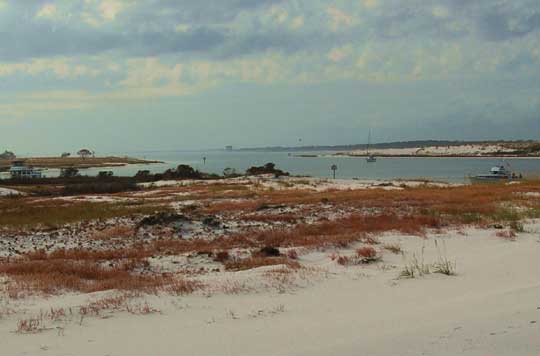
Professor Godwin had described the Ft. McRae anchorage, adjacent to the Pensacola Cut (which we will probably use to enter the Gulf when we get up the courage) as "super." Although the chart shows almost no water, this is the former "South Cut" which has eight to ten feet for a quarter mile or more. We dropped the Delta and took Nemo over to the beach and the ruins of Ft. McRae. The protection looks good from north and south, with some exposure to the east and west. There is bound to be some current, which should switch with the tides, but it doesn't look like a problem...a fine, beautiful anchorage. (Postscript: the anchorage got a bit rock-and-rolly that night as the tide came in, allowing the waves from the pass to bounce in, but by low tide at morning, all was calm and beautiful again. Between the beach, the ruins of the fort, and the decent protection, I still rank this high for an anchorage.)
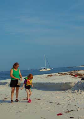
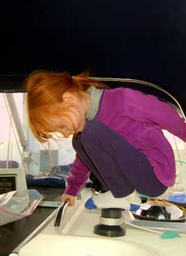
Annie says: A beautiful day on the beach. Well, at least an afternoon. I prefer to forget about the earlier hours of the day. Laura had a grand time hunting shells, being chased by waves and wading in the water. We have made a rule that only one item from each beach we visit can be collected. That leaves us a hope of not increasing the draft of the boat any further. Have you ever fed sea gulls? It is really neat to watch them catch a chunk of bread in mid-flight. We can hear the crashing waves of the gulf across the beach as we sit in the cockpit and relax.
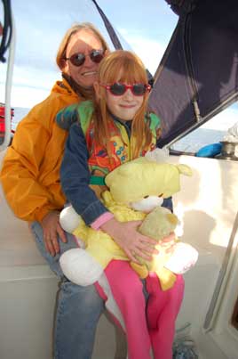
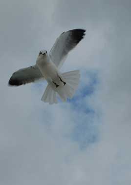
Photos:(1) Annie, Laura, Milo, and Chickadee. (2) One of the seagulls at Ft. McRae. (3) Neighbors at the anchorage. (4) Cocktail hour. (5) The Ft. McRae anchorage.
Sunday, December 4 - Pensacola
Laura really wanted to go back to the beach in the morning, but duty called. Our plan was to motor out into the Gulf and see what it was like out there, maybe hoist the sails for a while and see how things went. So we motored around to the pass and pointed the nose out into the swells. It was just after low tide so I had hopes that the waves coming in wouldn't be fueled by the water going out, but we were early for slack tide and soon the swells started to get uncomfortably large. We scrambled about looking for life jackets and harnesses. I didn't want to turn around in the steep green waves so out we went. At one point there were breakers a quarter mile off to each side, which kind of makes one think about what might happen if the engine should die at the wrong time (a good reason to have a sail up, not that we did). I thought that the waves might moderate, but when we reached the last set of markers about four miles offshore the seas were still steep and uncomfortable. Annie swears they were at least seven to eight foot seas, but I think they were six to seven.
Both girls were in the cockpit but feeling queasy. Annie and I were wearing scopolamine patches, while Laura had taken some motion sickness medication earlier. Then our customized Walker Bay Dingy, the Marlin, came loose on the foredeck and first Annie, then I, went up to secure it. Standing on the foredeck was a roller coaster ride with some real stomach-sinking, free fall moments. With Marlin secured, it was time to head to shore! We came back in with no problems (indeed, the swells had moderated with the slack tide). We motored just east of the pass and anchored for a trip ashore on Santa Rosa Island where we found tons of seashells and two translucent blue jellyfish--the floats from Portugese Man-o-Wars--washed up on the beach.
Around 3:00 PM I told the girls we needed to get going so we headed for downtown Pensacola. We ended up at the Bahia Mar Marina on Bayou Chico, which was $1.50/foot but a pleasant and well-sheltered place to spend the evening.
Annie says: Laura kept saying, "I told you we should have gone back to the beach today." When we talk of the lessons learned today, Laura sums it up: stay away from the big waves. She really is quite the trooper. Laura has started a quest to find an intact sand dollar (for good luck).
Monday, December 5 - Pensacola
Oh, we had some more learning to do today. We slept late, then did some chores on the boat, chatting for a few minutes on the VHF with Doug on Misty Blue, a sailboat we'd met at Dog River and seen motoring past the day before while we played on the beach and Santa Rosa Island. Looking at the charts, there were just two low bridges that prevented us from getting to Panama City on the Intracoastal rather than having to go out into the Gulf again. The forecast was for a front to come through that would keep the seas larger than we wanted to experience (especially after the day before), so we cast off and motored back down the Bay and east under the (65 foot) Pensacola Beach bridge. Around 3:00 PM we arrived at the Navarre Beach Bridge, which was charted as 50 feet. I was sure we would be able to get under the bridge and duck into one of the marinas to the east, but the gauge showed only about 49 feet of clearance, exactly what we needed, putting us into the same horrible limbo we'd experienced south of Demopolis. We made an approach to within about five feet and of course it looked bad, so I backed out and got a really lousy idea. With the winds still blowing 15-20 knots, we could hoist the sails, heel over, and easily get underneath. This was a risky idea for two reasons. First, our mainsail was still lacking an outhaul (we had been unable to set this up before leaving Sale Creek and unbeknownst to me the line I had tied two days before on Mobile Bay had come completely loose), so the sail pulled forward and looked more like a pillow. Second, I realized that the bridge would block the wind so that even if we were heeled over as we approached, the mast would come back up just as we went under at a high rate of speed. Abort! Abort! With the winds now blowing 20-25 knots, Annie steered while I tried to crank in the boom furler. Curses! The sail kept sliding forward on the boom, catching the battens so it wouldn't furl! As darkness fell I gave up and pulled the sail down by hand, tying it off (this process took several tries over 20 minutes) in a big mess around the boom. Annie and I were both souring on boom furling at this point.
It was now quite dark and we'd sailed a considerable distance back towards Pensacola, so our best option seemed to be to continue back to the Little Sabine Bay area just the other side of the Pensacola Beach Bridge. After an hour of motoring along in winds that kept getting stronger, we cleared the bridge and started looking for the narrow, allegedly shallow channel into Little Sabine where there might, or might not, be a marina or place to spend the night (the guidebooks were inconclusive on this point). I wasn't happy taking the boat into unknown waters in the darkness with the wind pushing us towards shore. Even with the radar, all we could find was one channel marker with nothing else to line up on. Our next plan was to seek shelter in the English Cove area a mile west of the bridge, but when we arrived the winds there were still gusting 15-20 knots. I went forward twice to drop the Delta but each time the wind blew the bow off before I got the anchor down. Reluctantly, I told Annie we needed to recross Pensacola Bay and return to Bahia Mar Marina. We knew the trip would be rough in the exposure of the Bay, but it was the only sure bet we had left for a good night's sleep.
At this point, a month into our trip, I had the first doubts about our plan to sail away. What we were doing out here, looking at high-rise hotels and waterfront palaces where people were relaxing in comfort in front of the television, while we bashed into four foot waves, cold and wet?  When I stood with my head up above the dodger the scene was one from those documentaries showing the bow of a boat crashing into wave after wave as the wind howled all around. On one hand, it was exhilarating. On the other wet and cold hand, it was miserable. Every minute or so a wave of spray came into the cockpit. My face and hair were wet with salt water; I could taste it on my lips. Against the wind and waves, we were making only four to five knots over the bottom. Finally, around 10:00 PM, we were back where we had started, tied to the dock at Bahia Mar. We'd been turned back first by the Gulf and now by the Intracoastal. Either way, it's not going to be easy to get further east.
We were bored, we said. We wanted adventure, we said. Only we didn't really want adventure every single day, and as Annie pointed out, this makes three days in row we'd learned just how little we know about cruising.
Annie says: There were several times in the dark hours that I questioned what we were doing. Then I realized (after we were docked) this was all part of the adventure. We had been lulled into the easy life as we cruised on the inland rivers, but this was the kind of situation for which we need to be prepared. Tomorrow we will re-group, evaluate some decisions, and continue. After all, Laura has yet to find an intact sand dollar.
Tuesday, December 6 - Pensacola
The big activity today (other than fixing the mainsail) was an attempt to heel the boat over by hoisting Nemo, loaded with the Delta anchor and 100 feet of chain, on the boom to see how far over the boat would go. If we could get over 15 degrees or so, that would make a significant reduction in height for those troublesome Intracoastal bridges. Unfortunately, hanging 250 pounds on the boom against the 4,700 pounds of lead in our keel didn't have a particularly dramatic effect, so it appears we will be going "outside" to get to Panama City.
I had never appreciated how much difference the phases of the moon make in the significance of the tides. If we wait until the low tide gets low enough to clear the bridges at Navarre Beach and Ft. Walton, we'll be waiting well over a week. Although we've got another front coming, the Gulf is forecast to be down to 1-3 foot seas by Saturday. In the meantime, we'll get the boat ready and wait.
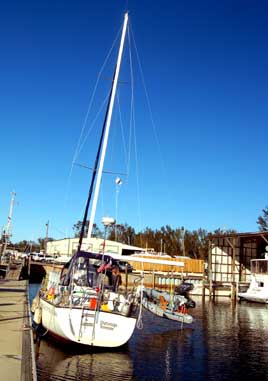
Photos:(1) Happier times at Santa Rosa Island. (2) Heeling just a little at Bahia Mar Marina.
Thursday, December 8 - Pensacola
We're anchored tonight in Big Lagoon, just outside the Ft. McRae cut, with the wind whistling outside and the boat rocking a bit in the small waves. It doesn't take much wind to rattle the plastic foil that runs up the rear of the mast for the furler, and it is definitely rattling tonight. Jerry and Ruby on Wind Dreams are a hundred yards to the north in a slightly more protected position; but it sounds like they need the rest since they dragged twice last night and didn't get much sleep. We had sailed down (yes, we actually turned off the motor and sailed down) from Bayou Chico to check on two marinas (Rod & Reel and Southwinds) here in Big Lagoon but they had been destroyed by Katrina--something I might have noticed when we passed by the first time if I had not been so distracted by the white sands and Gulf to the south. Wind Dreams arrived about the time we did and had anchored over on the Navy side of the Lagoon.
We spent last night at the Beach Marina in Little Sabine Bay, the refuge we had tried to enter on Sunday after our unsuccessful attempt to clear the Navarre Beach Bridge. We docked right at the Gulf side of the bridge to Pensacola Beach. Entrance yesterday afternoon was a lot easier, although we did run aground when nearly at the fuel dock. The rates weren't any better than Bahia Mar ($1.50/foot) but there was a very well stocked little store and deli on the premises. We did some work on the bimini and dodger this morning, fueled up (almost 17 gallons!), and left around Noon at low tide, touching bottom once on the way out. Laura, meanwhile, has become a big fan of Green Acres, which I'm not certain can be worked into the home school program or not. I saw an entire little pod of dolphins (three came over to play in our bow wave for a while) but Laura couldn't be enticed to come on deck, so intent was she on the latest episode.
The winds and seas (high since we got here) should die down tomorrow. The forecast for Saturday is good (seas 1-3 feet instead of the 6-9 we've been having) so if we don't make it across the Gulf to Destin tomorrow we'll very likely try it on Saturday. From Destin we've got a second day in the Gulf to get to Panama City and then, I think, we can make some Intracoastal miles without bridge troubles. However, we are running out of Intracoastal and will eventually have to make that overnight passage across the Gulf to Tarpon Springs or Tampa. I think perhaps now we're all more used to the boat bashing around in actual waves and feeling at least a little better about our prospects. Hard to believe we've been here for almost a week, but as our friend Tom Pride says, the trick is to "always, always, always wait for the weather window."
Saturday, December 10 - Destin
We slipped out the sleeping pass early this morning with Wind Dreams into a peaceful Gulf of Mexico and sped east down the coast. The water was 60-70 feet deep and colored that beautiful shade of turquoise that seems to pull the boat forward. We'd spent the day before anchored just east of the ruined docks of Rod & Reed Marina in Big Lagoon, looking for some shelter from the north winds, and we'd found it. After days of howling northers, what a relief to see that Pensacola sometimes had something else to offer!
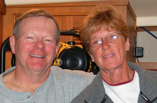
We let Wind Dreams negotiate the tricky inlet to Destin first (not that we really had much of a choice since the Island Packet goes so much faster than us). This inlet has it all: tricky currents, shifting sandbars, and shallow depths. Since the tide was coming in with very light waves, we had an easy time of it, but I'll breathe a little easier once we've gotten back out again. Two more sailboats, North Star and Shabu, followed us to anchor here in Destin Harbor. After hearing the friendly captain of Rain B help direct the latter arrivals to a good spot, we called him on the radio and soon thereafter were joining him for seafood at A.J.'s. Jim Brown had many tales to tell of living in the Virgin Islands, taking his boat up to Slidell, Louisiana for hurricane season only to be wiped out by Katrina (the boat had to be sent to Texas for $13,000 of repairs), tangling his anchor in an entire sunken bass boat here in Destin Harbor, and a doomed attempt to leave Destin last week into ferocious swells. With his 50HP engine flat out, his big Hunter was unable to climb one of the swells and slid backwards onto the rudder, breaking it off to just a stub. On Monday he goes to Gainesville to pick up the replacement and then, as we, he hopes to get further south to warmer weather. [Postscript: we crossed tracks with Jim on Rain B as he motored south across the Caicos Banks south of Provo the next April, so he did eventually get underway again.]
Pensacola was an interesting place despite the weather, but we met no other cruisers at Bahia Mar and felt very isolated. Teaming up with Jerry and Ruby on Wind Dreams gave us a boost and meeting Jim and his trusty canine, Chrissy, helped make this day a big success. If we haven't hooked a bass boat or some other sunken wreck (there are lots of them here in Destin Harbor) we hope to press on through the Gulf to Panama City tomorrow.
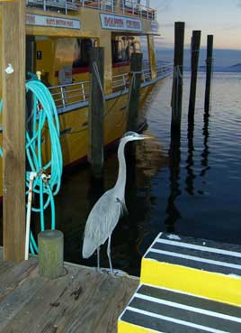
Photos:(1) Laura loves to spin on anything that, well, spins. (2) This heron at the charter boat docks in Destin is not particularly shy.
Monday, December 12 - St. Joe's Bay
Our third day in the Gulf, moving 20 miles further east from Panama City to St. Joseph Bay, was a little more unsettled. We had three foot seas all the way, with the wind from astern so that flying the sails did little to stabilize the boat. Yesterday was an easy 40 miles of motorsailing to Panama City, and we actually sailed with the engine off for a while until our speed dropped to four knots. We already feel slow traveling with Wind Dreams, who had gotten a mile ahead of us, but realistically when you're trying to make the next inlet in the daylight you can't afford to slow down much. We spent the night at Panama City Municipal Marina, a very well equipped place. The staff were very friendly, with three helping us tie up a the fuel dock (we scarfed down almost ten gallons, big spenders!) and two helping us tie up at the slip. We really can't afford to spend every night in a marina (this one was $1.25/foot, but at least it wasn't $1.50 with a 40 foot minimum like the Bay Pointe Marriot resort nearby) but we badly needed to do some laundry.
We've been either following or being followed for the past three days by the sailing vessels Shabu and North Star. I believe we met the crew of Shabu at Dog River but strangely we haven't had any real contact with them lately beyond just seeing their mast off the distance. After our parade of our boats (in keeping with our racing heritage, we were about a mile behind the others) entered St. Joseph Bay, the other two yachts anchored just around the corner from the inlet. Wind Dreams did the same, but Seaductress continued about three miles down the beach to Eagle Harbor. We've got decent protection from the west, which is where the wind is supposed to be tonight, no better or worse than where the others are tonight. The advantage here is that we could dingy ashore to a small park and visit the Gulf-side beach. Annie and Laura had a fine time beachcombing, as usual, finding all kinds of shells, fish bones, horseshoe crab shells and the like. Most of this area is a wilderness preserve and the deserted beach was wonderfully wild and windy.
Tomorrow I believe we'll cross the bay and enter the Gulf County Canal, a five mile ditch that will reconnect us to the Intracoastal, Apalachicola, and finally Carrabell, the jumping-off point for the overnight trip across the Gulf down to Tarpon Springs. All our books still list a 50 foot bridge blocking the route, but the Maptech map clearly shows the old bridge gone and a new, higher one in its place. And that's good news because the Gulf is going to be rough again for a few days according to the forecast.
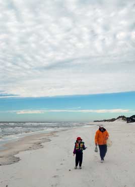
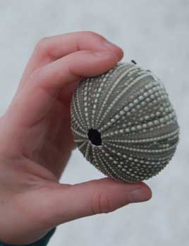
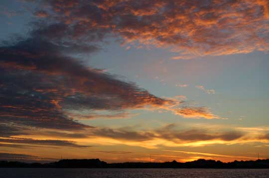
Photos:(1) Laura finally got to go back to the beach. (2) This sea urchin shell was very fragile and Laura cried when it got crushed after we got it back to the boat. (3) Sunset this evening over Eagle Harbor.
Tuesday, December 13 - Apalachicola
Sometime past midnight the wind clocked around from West to North and (alas!) Northeast, which was one direction none of us anchored in St. Joseph sound desired. Seaductress had plenty of water to swing any direction except southeast, so she was fine, although rocking in the waves. North Star, a couple of miles up the beach, was not so lucky and went aground when they swung into shallow water. This cost them a lot of sleep but they were able to get themselves free in the morning (lucky thing, since Towboat U.S. quoted $1,600 for the job).
We set out across the bay and entered the Gulf County Canal, five miles of waterway that's straight enough to see one end from the other, then rejoined the very scenic Intracoastal Waterway. For the next few miles we enjoyed blue skies, coffee-colored water, cypress trees, and "impenetrable swamp" in full technicolor. Around 2:30 PM we arrived in the metropolis of Apalachicola and docked at Deep Water Marina. The rest of the "Boatilla" from St. Joseph Bay (Wind Dreams, Shabu, North Star, and Anticipation) settled in just a hundred yards away at Scipio Creek Marina. Rumor has it that our former neighbors (as Laura calls them), Living Well are just a half-days travel behind us as well. Although all the boats have the same vague destination (someplace warmer), there are many opinions on the best route to achieve that goal: go wait at Carrabelle, cross the Gulf from here, or take the Big Bend Route and avoid the long crossings altogether.
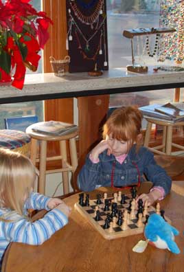
Photos:(1) Apalachicola is a funky little town. (2) Chess at the Cafe con Leche Internet Cafe. (3) Jerry and Ruby of Wind Dreams.
Next Two Weeks | Previous Two Weeks | Start of Log


Copyright © 2007 by Rodger Ling.
All rights reserved.
